Two weeks ago, I drove out of the valley for a hike for the first time in a long time. I went north, stopping just short of Payson, in the Mazatzal Wilderness. The tallest mountain in that area is, predictably, Mazatzal Peak, and there's a series of trails you can take that form a loop around it.
It was a 90-minute drive to get there, and we arrived at 6:30, just after the sun broke over the horizon. I was surprised to find two cars already there.
The first trail traveled up a small canyon.

The trail wound back and forth, traveling up the steep walls of the canyon as best as it could. There was a lot of climbing to do: these first four miles of trail rose nearly two thousand feet in elevation.

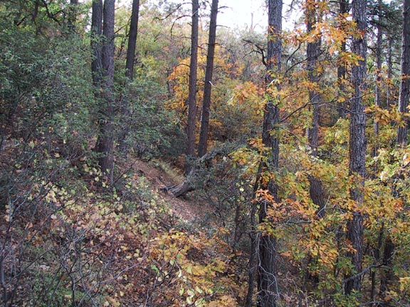
At one point, the trail dipped back into a surprisingly green branch of the canyon.

There were two waterfalls tucked away in this area, though there was only a trickle of water coming down. Standing at the bottom of one of them, the rocks made an interesting frame for a dead tree high above.

The trail finally leveled out, and we broke out of the canyon's shadow.

Before moving on, an overlook gave a great view into the canyon we had just came out of. If you look at the full-size version of this picture, you can see the trail snaking up the right side.

Some of the cacti were just beginning to bloom.

The trail was dotted with these absurdly tall yucca things. Each had a single 20-foot-tall stalk growing out of a ball of thick green spikes on the ground. I'm pretty sure they're chaparral yuccas, but I read that they only grow in southern California and Baja California. If that's so, I have no idea what these things are.


After the canyon, the trail emerged into a scrubby wasteland of scorched trees, the result of a wildfire in 2004. This one was caused by a lightning strike, not careless campers.

For comparison, here's a picture taken in 1998 by HikeArizona.com user Fritzski, of what was once a "shady pine and oak forest."
We wouldn't see any shade for the next eight miles.

After what seemed like forever, we came into view of Mazatzal Peak itself.

The trail never goes to the top. Instead, it tops out at a saddle nearby, 2,400 feet higher than the trailhead. It's still a good view.

There were a pair of springs just past the saddle. It was the first water we'd seen since the waterfalls, ten miles before.

After that, it was five more miles and a long descent back to the car. That was the most frustrating part of the hike. We could
see the highway, way far off in the distance, never seeming to get any closer. It was the longest and highest hike I've ever done. Fifteen miles was really too much for me, especially with all the elevation change.

We finally got back to the car at 4:00 PM. We'd seen a total of five other hikers.


 (FWIW, the "lonesome pine" and the cactus blossom captures are my favorites--I've only kicked around in Big Bend a little, so that's really an exotic landscape for me.)


 Post #1 by scratchpaddy
 Similar Threads


