 Originally posted by johnmflores
I can't really blame people for making decisions where to live and work that benefit themselves and their families. It take a person especially dedicated to larger social causes to place those issues ahead of their immediate loved ones, and there's no practical way to convince a significant number of people to do that.
That's where the role of government lies - to create the conditions where rehabilitating and rejuvenating depressed urban areas makes more sense (financially and otherwise) than razing another 400 acres of farmland to create the next set of McMansions, condos and big box retail center.
The fact that our nation's capital and many of its older cities lie in a state of urban squalor - DC, Baltimore, Trenton, Troy NY, New Haven CT, etc... is a failure of leadership and a national disgrace.
Yup, its sad

I think the only thing that saves my city from this is the fact that you have to drive about 30 miles across a lake or swamps to find the undeveloped farm land... And even that hasn't deterred some of the most hardcore urban deserters.
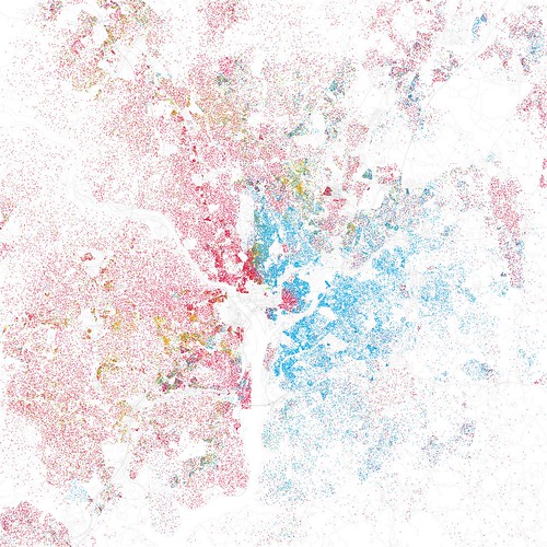
Originally posted by MRRiley I'd like to know the precise methodoly in calculating the color of the dots. One comment on the flickr page discussing the DC Metro map claims that each dot was an aggregate representing 25 people. This would hide a lot of detail if only the majority was identified in each group. If 13 people in the dot group were white and 12 were black the dot would be coded as red. This would effectively hide a near equal number of black citizens in that group thus seriously skewing the observable results
I don't think the map mixes races, it would simply put two dots 1 red and 1 blue. If you zoom into the original version on flicker you can see that even in areas where it is highly concentrated there are a couple of dots where you have pockets of minorities living in an otherwise all white or all black neighborhood. For example there are a few blacks and asians living in the capital hill neighborhood which is 89% white and there are a smattering of whites and hispanics living in Anacostia.
Originally posted by Ira It's like saying that Las Olas Boulevard in Ft. Lauderdale is 100 times richer than Oakland Park Boulevard--even tough the latter is a few blocks north of the former.
That probably is true. But the fact that someone from Oakland Park is able to walk a few blocks up to Las Olas and find a good job creates a huge opportunity for them compared to if they had to catch 4 different buses to find something outside of a fast food joint.
Originally posted by mel And the majority of Federal workers (like my family) live about 3 to 5 counties out of the city because we can't afford to live in within two counties of DC.
I don't know whether it is the federal civilian workers, contractors, spooks, politicians, or influence peddlers but there is a huge amount of money being sucked into the District from the rest of the country because the main industries there are bureaucracy and defense. The idea that the federal government is going to solve the problems associated with income inequality by redistributing anywhere other than DC is incredible because there is no record of them ever doing any such thing.


 Similar Threads


