Forgot Password
Pentax Camera Forums Home
 

Reply
Show Printable Version 1116 Likes Search this Thread
05-11-2019, 03:21 AM   #781
Loyal Site Supporter
jacamar's Avatar

Join Date: Feb 2011
Location: Toronto
Photos: Albums
Posts: 3,443
QuoteOriginally posted by SunValley Quote
Wow looks like they found a way to feed them rocks!

Very nice image, bravo.
Thanks. I think the vegetation would be more lush if not for the goats!

05-11-2019, 06:51 AM - 1 Like   #782
Site Supporter
Site Supporter


Join Date: Jan 2016
Location: Fulton County, Illinois
Posts: 3,736
QuoteOriginally posted by SunValley Quote
Wow looks like they found a way to feed them rocks!

Very nice image, bravo.
Meat from those rock-fed goats must command a high price at gourmet shops!
05-19-2019, 01:52 PM - 2 Likes   #783
amateur dirt farmer
Loyal Site Supporter
pepperberry farm's Avatar

Join Date: Dec 2014
Location: probably out in a field somewhere...
Photos: Gallery | Albums
Posts: 41,780
farm around the corner from us:

05-19-2019, 02:32 PM   #784
Site Supporter
Site Supporter


Join Date: Jun 2013
Location: Montreal, Canada
Photos: Gallery | Albums
Posts: 574
QuoteOriginally posted by pepperberry farm Quote
farm around the corner from us:
Look at that corn going! Out here spring is so slow, most of it is still in the bags. Nice colors!

05-19-2019, 02:59 PM - 4 Likes   #785
amateur dirt farmer
Loyal Site Supporter
pepperberry farm's Avatar

Join Date: Dec 2014
Location: probably out in a field somewhere...
Photos: Gallery | Albums
Posts: 41,780
QuoteOriginally posted by SunValley Quote
Look at that corn going! Out here spring is so slow, most of it is still in the bags. Nice colors!

thank you - winter wheat is about to start turning here

05-27-2019, 02:06 PM - 3 Likes   #786
Site Supporter
Site Supporter


Join Date: Jan 2016
Location: Fulton County, Illinois
Posts: 3,736
GRAZER'S SPECIAL
-- all this week! --


Clover, with dew drops,
and cottonwood tree seed
garnish!


K-R + F-35-70
05-31-2019, 05:42 PM - 2 Likes   #787
Site Supporter
Site Supporter
paulh's Avatar

Join Date: Sep 2010
Location: DFW Texas/Ventura County, CA
Photos: Gallery | Albums
Posts: 33,319
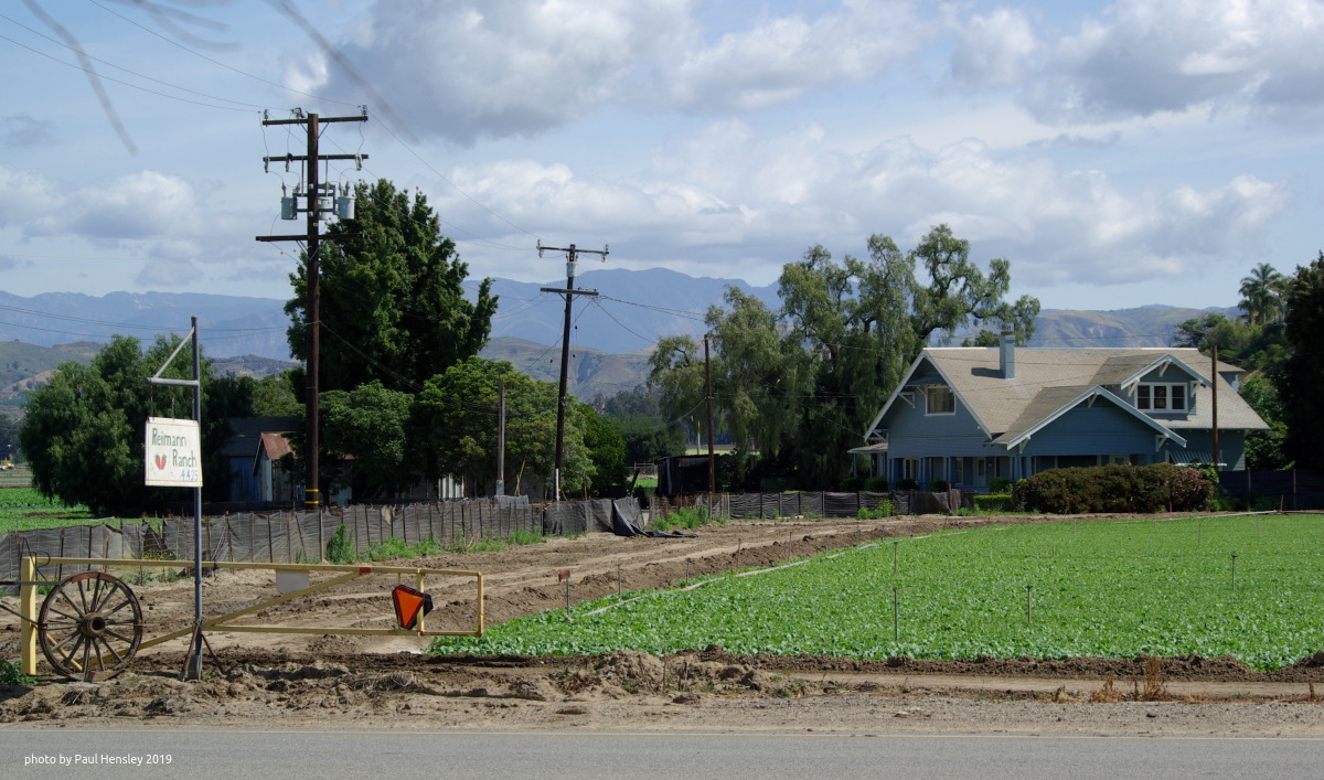
This farm is situated very near my location in Ventura County, Calif. The place is known for peppers, onions and beans, among other crops. DAL 55-300 on K10D:


06-07-2019, 04:53 AM - 3 Likes   #788
Loyal Site Supporter
KC0PET's Avatar

Join Date: Oct 2015
Location: Central Missouri
Photos: Gallery | Albums
Posts: 6,273
Yes, this is normally a farm field. One of the unfortunate realities of bottom land farming. We are seeing the highest water here since 1995.


Actually as I look we have broken the 1995 record. This is the highest flood since the Great Flood of 1993.

---------- Post added 06-07-19 at 07:08 AM ----------

Here is another view from on top of the bluff in the above photo. Hard to imagine how much water it takes to fill up the river bottoms like this.

06-07-2019, 11:13 AM - 1 Like   #789
Site Supporter
Site Supporter


Join Date: Jan 2016
Location: Fulton County, Illinois
Posts: 3,736
Alas, levees give a false sense of security when it comes to years with record rains in a river's watershed. Very sad for folks with homes,structures, livestock in the floodplain.

In 1881, the flooding Mississippi changed channels in its flood plain near the village of Kaskaskia, Illinois, which had years earlier been the first capital of the state in 1818, and in the process the river destroyed almost all of the town, and left what little wasn't destroyed on the Missouri side of its new flow. To this day, a few square miles of Randolph County, Illinois, are on the west side of the Mississippi, residing as a little cut-out at the corners of of St. Genevieve and Perry Counties in Missouri. Of course, there probably wasn't much of a levee system then, though it was believed a Native American town had been on the site for hundreds of years or more prior to the arrival of European traders and settlers. Post the modern levee system, however, the remnant village of Kaskaskia flooded badly (but didn't wash away again) in the Great Flood of 1993 that you mentioned.
06-07-2019, 03:19 PM - 2 Likes   #790
Loyal Site Supporter
KC0PET's Avatar

Join Date: Oct 2015
Location: Central Missouri
Photos: Gallery | Albums
Posts: 6,273
QuoteOriginally posted by goatsNdonkey Quote
Alas, levees give a false sense of security when it comes to years with record rains in a river's watershed. Very sad for folks with homes,structures, livestock in the floodplain.

In 1881, the flooding Mississippi changed channels in its flood plain near the village of Kaskaskia, Illinois, which had years earlier been the first capital of the state in 1818, and in the process the river destroyed almost all of the town, and left what little wasn't destroyed on the Missouri side of its new flow. To this day, a few square miles of Randolph County, Illinois, are on the west side of the Mississippi, residing as a little cut-out at the corners of of St. Genevieve and Perry Counties in Missouri. Of course, there probably wasn't much of a levee system then, though it was believed a Native American town had been on the site for hundreds of years or more prior to the arrival of European traders and settlers. Post the modern levee system, however, the remnant village of Kaskaskia flooded badly (but didn't wash away again) in the Great Flood of 1993 that you mentioned.
That is an interesting situation. I have been over to Kaskaskia a time or two from St. Mary, MO. You drive over the historic channel to get there, not much there maybe a dozen homesteads and farmland. I know the levee system on the Mississippi River was started in the mid-1800s, much of anything before that was piecemeal and probably not very high. The whole story of the Mississippi River flood control is interesting, there is a book called, "Rising Tide" by John M Barry that is a great read and gives a great review of many things leading up to the Flood of 1927.

Of course the problem now is that when the water does go over levees there are very large volumes of water waiting to get in so a small trickles can turn into a big hole in the levee in a hurry. And then there are the seeps through weak spots that take the whole thing from the bottom up.

Looking at the hydrograph page for Chester, IL, it looks like Kaskaskia is a true island right now with their road access from MO under water.
06-07-2019, 03:44 PM - 1 Like   #791
Site Supporter
Site Supporter


Join Date: Jan 2016
Location: Fulton County, Illinois
Posts: 3,736
QuoteOriginally posted by KC0PET Quote
That is an interesting situation. I have been over to Kaskaskia a time or two from St. Mary, MO. You drive over the historic channel to get there, not much there maybe a dozen homesteads and farmland. I know the levee system on the Mississippi River was started in the mid-1800s, much of anything before that was piecemeal and probably not very high. The whole story of the Mississippi River flood control is interesting, there is a book called, "Rising Tide" by John M Barry that is a great read and gives a great review of many things leading up to the Flood of 1927.

Of course the problem now is that when the water does go over levees there are very large volumes of water waiting to get in so a small trickles can turn into a big hole in the levee in a hurry. And then there are the seeps through weak spots that take the whole thing from the bottom up.

Looking at the hydrograph page for Chester, IL, it looks like Kaskaskia is a true island right now with their road access from MO under water.
Between the levee system and the lock-dam-pool system used to maintain the shipping channel, there is a great difference between our Mississippi and the wild one described in Mark Twain's book Life on the Mississippi., which sometimes made significant changes is a few areas between a river pilot's upstream passage and his next downstream passage. But then, in these high-water years, the river reminds us that it hasn't given up all of its wildness, and we forget that at our peril.

I live near the Illinois River, and geological evidence shows that during one of the inter-glacial periods, the Mississippi turned east a bit below the Quad Cities, and flowed over to what is now a middle point on the Illinois River's channel and then resumed its southerly flow down it. Had it not reverted back to the western channel eventually, I'd be living in Iowa!
06-07-2019, 05:03 PM - 1 Like   #792
Loyal Site Supporter
KC0PET's Avatar

Join Date: Oct 2015
Location: Central Missouri
Photos: Gallery | Albums
Posts: 6,273
QuoteOriginally posted by goatsNdonkey Quote

I live near the Illinois River, and geological evidence shows that during one of the inter-glacial periods, the Mississippi turned east a bit below the Quad Cities, and flowed over to what is now a middle point on the Illinois River's channel and then resumed its southerly flow down it. Had it not reverted back to the western channel eventually, I'd be living in Iowa!
Ack
06-15-2019, 11:42 AM - 2 Likes   #793
Site Supporter
Site Supporter
paulh's Avatar

Join Date: Sep 2010
Location: DFW Texas/Ventura County, CA
Photos: Gallery | Albums
Posts: 33,319
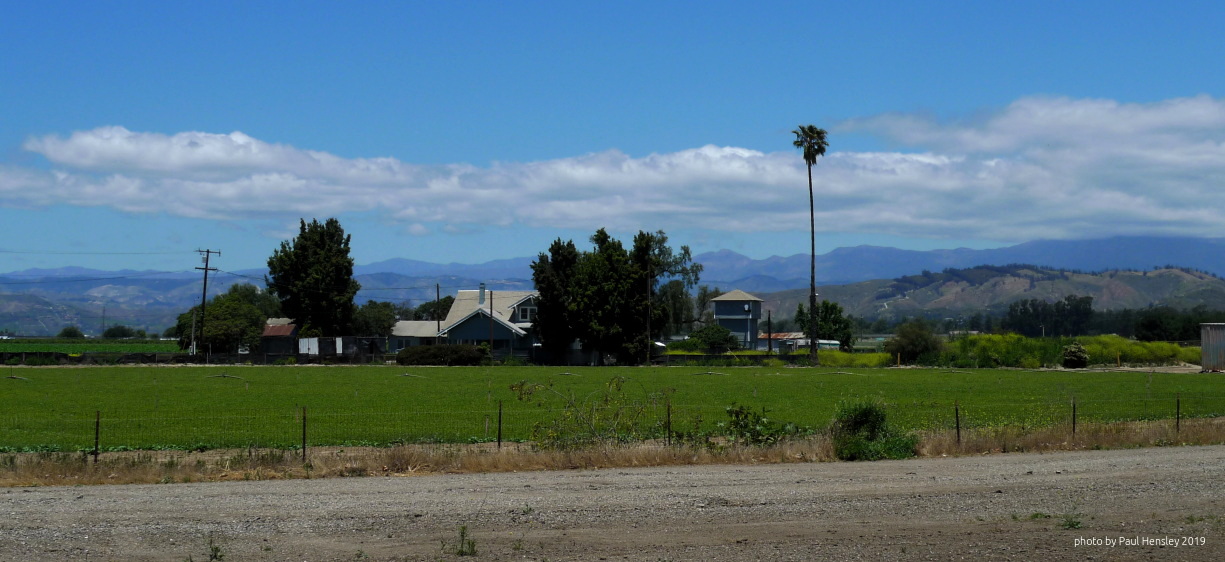
Nearby farm in Camarillo, Calif. This is the same farm seen in my photos above (post 787):
06-15-2019, 04:30 PM - 2 Likes   #794
Loyal Site Supporter
WPRESTO's Avatar

Join Date: Aug 2010
Location: Massachusetts
Photos: Gallery | Albums
Posts: 59,142

---------- Post added 06-15-19 at 07:37 PM ----------

QuoteOriginally posted by goatsNdonkey Quote
Between the levee system and the lock-dam-pool system used to maintain the shipping channel, there is a great difference between our Mississippi and the wild one described in Mark Twain's book Life on the Mississippi., which sometimes made significant changes is a few areas between a river pilot's upstream passage and his next downstream passage. But then, in these high-water years, the river reminds us that it hasn't given up all of its wildness, and we forget that at our peril.

I live near the Illinois River, and geological evidence shows that during one of the inter-glacial periods, the Mississippi turned east a bit below the Quad Cities, and flowed over to what is now a middle point on the Illinois River's channel and then resumed its southerly flow down it. Had it not reverted back to the western channel eventually, I'd be living in Iowa!
Hopefully I will refrain from typing out two to three hours worth of lecture once given to Geology 101 students about the dynamics of stream flow. Here are basics concerning levees.
1) the stream economy formula (discharge = width X depth X velocity) always balances because it is a description, not a prediction or theory
2) when levees are constructed, you are trading less width for greater depth and velocity
3) consequently the stream rises higher behind a levee than it did before the levee was built, and this also increases velocity because the slope (or vertical drop) to all points downstream is increased
4) another way to think of it: levee construction creates a bottleneck causing water to backup on the upstream side (= at least temporarily) the decrease in width caused by levee construction decreases the discharge flowing past the point where the levees are built, which causes impoundment of some of the discharge approaching the levees from upstream
5) this means upstream areas will suffer worse floods as a consequence of levees constructed downstream;
6) therefore upstream towns/communities will be obliged to construct levees, which will cause worse flooding upstream of them.

etc. etc. etc........

Last edited by WPRESTO; 08-10-2019 at 04:53 AM.
06-15-2019, 06:13 PM - 3 Likes   #795
Site Supporter
Site Supporter
wtlwdwgn's Avatar

Join Date: Jan 2007
Location: Billings, MT
Photos: Gallery | Albums
Posts: 13,853
Gotta get those farm pics in before they pave over them!
Reply

Bookmarks
  • Submit Thread to Facebook Facebook
  • Submit Thread to Twitter Twitter
  • Submit Thread to Digg Digg
Tags - Make this thread easier to find by adding keywords to it!
agriculture, aka, bet, channel, corn, discharge, dishes, electricity, flood, flow, illinois, image, panels, power, river, roof, satellite, stream, thread, turbines, velocity, water, width, wildlife, wind, windmills

Similar Threads
Thread Thread Starter Forum Replies Last Post
Black & White Marshall, IN. A small small farming town. arbib Post Your Photos! 0 01-03-2011 09:08 PM


All times are GMT -7. The time now is 04:36 PM. | See also: NikonForums.com, CanonForums.com part of our network of photo forums!
  • Red (Default)
  • Green
  • Gray
  • Dark
  • Dark Yellow
  • Dark Blue
  • Old Red
  • Old Green
  • Old Gray
  • Dial-Up Style
Hello! It's great to see you back on the forum! Have you considered joining the community?
register
Creating a FREE ACCOUNT takes under a minute, removes ads, and lets you post! [Dismiss]
Top